


At a glance
- Australian beaches are categorized as dissipative, intermediate, or reflective, based on wave energy and sediment size.
- Understanding coastal wave dynamics, water levels, and beach processes is important to understand climate change impacts and required adaptation.
- Climate change will exacerbate these effects, increasing storm intensity and sea levels, requiring coastal managers to implement tailored strategies for adaptation and coastal protection.
- Coastal managers need to integrate these processes into hazard assessments and adopt site-specific strategies to mitigate the risks posed by rising sea levels and increased storm activity. Understanding these dynamics is essential for planning sustainable adaptation measures.
more from the Information Manual: Coastal waves, water levels, beach dynamics and climate change
Australian beaches
Australian beaches are categorised as dissipative, intermediate, or reflective, based on wave energy and sediment size.
- dissipative beaches, characterised by wide surf zones, high wave energy, and fine sediments, exhibit persistent alongshore currents
- reflective beaches, with lower energy and coarser sediments, have minimal currents.
- intermediate beaches, where wave energy and sediment size vary, are the most dynamic and prone to rapid morphological changes during storms.
Understanding the beach type is essential for coastal managers as it informs any adaptation response to storms and sediment movement. Intermediate beaches, with their mobile sandbars and rip channels, are particularly vulnerable to significant storm impacts.
Australia spans tide‑modified/dominated systems in the tropical north, swell‑dominated temperate coasts in the south, local exposure and tidal range differ markedly, which also shapes erosion and inundation risk.
Understanding waves and currents
Coastal waves are primarily driven by wind and classified into sea waves (locally generated) and swell waves (generated from distant winds). Sea waves are short and choppy, while swell waves have longer, continuous crests.
'Significant wave height', which measures the largest waves, is a critical indicator for assessing coastal conditions.
Local conditions determine how waves influence the coastal and coastal processes. As waves move from deep water to the shore, they transform through:
- refraction: waves 'bend' as they approach the coast due to changing depth of the seafloor
- diffraction: wave energy spreads laterally as they pass obstructions
- shoaling: as waves enter shallow water, their height increases and speed decreases, intensifying their impact on the shore.
Waves break in the surf zone when their crests move faster than the wave form, generating currents like undertow and longshore currents. These currents transport sediment along and across the shore, contributing to beach erosion and reshaping the coastline.
Waves had different breaking styles – spilling, plunging, and surging – are determined by beach slope and wave steepness, which influence the beach's vulnerability to erosion.
about CoastAdapt's case study on:
- the King Tide citizen science project
- projected increases in sunny day flooding
- surfers and Endangered Waves
Other factors that affect coastal water
Coastal water levels, which significantly influence beach dynamics, are affected by various factors, including the following.
- Tides: astronomical tides cause regular fluctuations in water levels
- Barometric setup: low-pressure systems during storms elevate water levels.
- Wind setup: winds push water towards the coast to further raise coastal water levels
- Wave setup and runup: breaking waves raise water levels near the shore and contribute to coastal erosion
- Compound events: when surge + wave setup/runup + heavy rain/river discharge coincide near high tide, the resulting storm tide and compound flooding drive the most damaging coastal inundation.
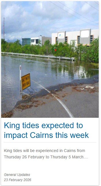
King tides
King tides are the highest tides of the year—an expression of the Highest Astronomical Tide (HAT) under average weather, driven by the alignment and distance of the Earth–Moon–Sun system.
They are predicted, natural, and not caused by climate change, but rising mean sea level increases their impacts on low‑lying areas. However, some coastal locations are increasing experiencing problematic king tides.

Some coastal locations are increasing experiencing problematic king tides. For example, Cairns Regional Council in Far North Queensland now publishes King Tide warnings.
- © Cairns City CouncilCairns tide warning
Some coastal locations are increasing experiencing problematic king tides. For example, Cairns Regional Council in Far North Queensland now publishes King Tide warnings.
© Cairns City Council