


At a glance
- The coast is a dynamic environment, with active coastal processes including shoreline change, marine inundation and associated landform change.
- These sediments are constantly redistributed by hydrodynamic forces, including wave action and tidal currents.
- Coastal managers need to understand sediment dynamics to better manage coastal change.
about the impacts of climate change on beach and estuary sediments in CoastAdapt
The coastline is a dynamic environment
The Australian coastline is a dynamic and complex environment shaped by the continuous interaction of waves, tides, and currents with coastal sediments. These processes drive shoreline movement, marine inundation, and the evolution of landforms such as beaches, dunes, and tidal flats.
Coastal sediments – primarily sand grains – occur along the entire coast and exhibit a wide range of origins, structures, sizes, and chemical compositions (Short, 2020). These sediments are constantly redistributed by hydrodynamic forces, including wave action and tidal currents. Importantly, sediment accumulations can influence these water motions, creating feedback mechanisms that contribute to the development and transformation of coastal landforms.
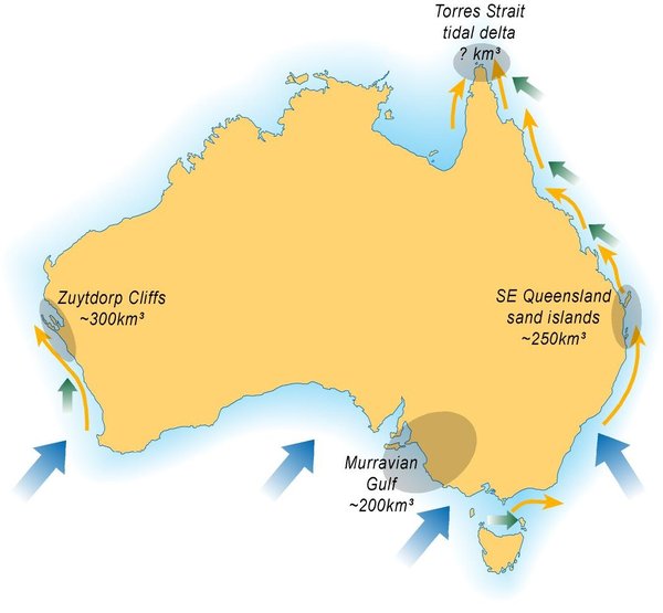
Figure 1: Major longshore sand transport and deposition systems around Australia. The orange arrows indicate major longshore sandtransportation pathways; the blue arrows show dominant southerly swell direction; the green arrows dominant trade-wind wave direction; andthe shaded areas indicate major regional sediment accumulation sites.
- © Short and Woodroffe 2009Sediment transport Australia

Figure 1: Major longshore sand transport and deposition systems around Australia. The orange arrows indicate major longshore sandtransportation pathways; the blue arrows show dominant southerly swell direction; the green arrows dominant trade-wind wave direction; andthe shaded areas indicate major regional sediment accumulation sites.
© Short and Woodroffe 2009
more in the Information Manual on Coastal Sediments, which includes technical and management information.
for your area using Shoreline Explorer in CoastAdapt.
how to use Shoreline Explorer's sediment compartment approach. This national framework was developed using coastal sediment compartments – discrete coastal units where sediment behaves similarly – to better understand beach system dynamics.
how to use Shoreline Explorer's Smartline for coastal risk assessment.
more coastal mapping tools such as Geoscience Australia's DEA Coastlines, which has mapped shoreline changes across the Australian coastline since 1988.
It shows how coastal features such as beaches, sandspits, river mouths, and tidal flats have expanded or eroded over time.
How this has been applied in a nationwide study: the Geoscience Australia's DEA Coastlines data found that 22% of Australia's non-rocky coastline has retreated or grown significantly since 1988, with 16% changing at greater than 0.5 m per year.
Soft shore environments – including beaches, foredunes, coastal banks, and terraces – are particularly sensitive to these dynamics. They are the first to experience the impacts of climate change, such as sea-level rise and altered weather patterns. These changes can lead to both erosion and accretion, significantly affecting coastal land use, infrastructure, and natural ecosystems. For instance, the degradation of fringing wetlands and dune systems can result in the loss of critical ecosystem services
Some changes to soft shores occur over long to very long time frames (decades to millennia), with substantial response expected to occur due to projected climate changes. Present day variability of soft shores, and their sensitivity to climate change, determine that an understanding of coastal dynamics is essential to coastal planning and adaptation.
Most beaches and dunes currently have local erosion and recovery cycles that vary around a stable mean shoreline position, while some shorelines are eroding and a few shores are building seaward.
Wave climates are predicted to change all across southern Australia, particularly due to enhanced southern ocean wave energy, which is likely to alter sediment transport pathways across Australia.
Coastal development that encroaches on dynamic coastal processes can lead to unintended consequences in adjacent areas, such as increased erosion, particularly where sediment transport pathways have been interrupted.
Failure to consider sediment transport processes across regional scales can be costly; it can result in permanent change to beaches and soft shores. For example, the northern drift of sand from Busselton to Mandurah on the Western Australia coast was interrupted in the 1990s for a canal estate development called Port Geographe. This resulted in erosion to the northern beach that threatened roads and houses and a build-up of sand and rotting seagrass against the updrift training wall.

At the mouth of the Tweed River on the border between Queensland and New South Wales, he construction of a training wall in the early 1960s blocked the northward movement of sand over the state border and into the Gold Coast. This sand would normally have maintained the beaches in the region. The solution, including a seawall, dredging of sand and a permanent pumping system, has been a large and ongoing expense.
Tweed bypass

At the mouth of the Tweed River on the border between Queensland and New South Wales, he construction of a training wall in the early 1960s blocked the northward movement of sand over the state border and into the Gold Coast. This sand would normally have maintained the beaches in the region. The solution, including a seawall, dredging of sand and a permanent pumping system, has been a large and ongoing expense.
more about the Tweed River sand bypass, has been operating for more than two decades and is one of the largest fixed sand bypassing schemes in the world.
Sand deposition areas can also present problems for coastal management, for example accumulating and shifting sandbars in tidal channels and estuaries can become dangerous for navigation. One place experiencing this is Georges Bay in eastern Tasmania, which is a sand sink and also an important sheltered port; the shifting and expanding sand bars in the tidal channel are a navigation hazard.
Managing shorelines through a coastal sediment compartments
A common way to manage a local section of shoreline is through a coastal compartment approach that was developed for use in Australia in 2015. It is also used in the United States, United Kingdom and Eerope.
This approach divides the coast into areas of relatively uniform landforms and sediment processes. The boundaries are based on local landmarks serve as natural barriers to sediment transport, allowing each compartment to be treated as a semi-closed system with identifiable sources and sinks of sediment.
It is mainly used for open coastlines and does not cover detailed sediment dynamics in estuaries or coastal lakes.
how to use a sediment compartments approach in CoastAdapt.