


At a glance
- Best suited to first‑pass or screening assessments at regional or large‑area scales, not detailed design or prediction.
- Uses high‑quality elevation data (commonly LiDAR) and tidal reference levels to map potential inundation extents quickly across scenarios.
- Does not account for dynamic processes such as storm surge, waves, tides in estuaries or flood defences, meaning results are indicative rather than definitive.
What is bathtub inundation modelling
Bathtub (or bucket‑fill) inundation modelling is a simple, commonly used method to identify land areas that could be flooded as sea levels rise. Like filling a bathtub, the models simply “fills” land to a specified water level and overlays this existing topography.
'Bathtub inundation modelling' is also known as 'bathtub modelling' or as 'bucket-fill modelling'.
Bathtub models are based on elevation. Land that sits adjacent to the sea and below a chosen water level – usually present day mean sea level plus a projected sea‑level rise amount – is separated from higher ground using a deterministic line. The lower areas are then mapped as inundation zones, often shown in light blue.
The most important requirement for bathtub modelling is a high‑quality digital elevation model (DEM). The accuracy of a DEM depends on its spatial resolution and vertical precision. Airborne LiDAR is now widely used to produce detailed DEMs, typically with 1 m horizontal resolution and vertical accuracy better than 0.2 m, allowing fine‑scale land features to be mapped.
Because sea level at a given time will vary by location due to tides, bathtub models commonly reference elevations to tidal datums such as mean sea level or mean high water. Bathtub models that include these tidal variations will have more accurate zones of inundation on the land surface.
One issue to consider with bathtub modelling is that sometimes low‑lying areas that are not connected to the sea may be identified as at risk of inundation. Some models correct for this by filtering out isolated depressions to ensure they show only areas that could realistically be flooded by rising seas.
how bathtub modelling is used in CoastAdapt's inundation mapping tool Sea level Rise and You
another example of use: Coastal Risk Australia.
The Coastal Risk Australia inundation tool uses high-resolution LiDAR data and a simple bathtub model linked to Highest Astronomical Tide data to enable users to explore the potential inundation from sea-level rise scenarios or other high water level events.
Bathtub modelling: a conservative first look.
Benefits of bathtub modelling: a glass half-full
Bathtub modelling is a simple and readily implementable method for identifying potential inundation from sea‑level rise.
- It enables rapid assessment of inundation extents across multiple sea‑level rise scenarios, making it suitable for first‑ or second‑pass risk assessments.
- The approach is well suited to large‑area and regional‑scale risk mapping.
- In areas where detailed local data or advanced modelling are unavailable, it may be the only feasible method for identifying inundation risk.
- Bathtub models can be easily integrated with GIS and local topographic datasets to assess exposure of land, assets and infrastructure.
- The method is relatively easy to understand and communicate, making it accessible to a broad range of practitioners, decision‑makers and stakeholders
Limitations of bathtub modelling: a glass half empty
Bathtub modelling is useful for a first pas screening but not more complex decision-making as it has several limitations.
Bathtub modelling does not consider:
- a realistic ocean surface: it assumes the ocean surface is calm
- any change to tidal flows in waterways, such as estuaries, that will result from different coastal configurations in some locations.
- existing sea walls and other protective structures, including some flood mitigation structures. At present there is not a national database of such structures in Australia.
- the influence of wind and waves, and such models therefore provide limited guidance about flood risk from an extreme event, such as a storm surge.
- the effects of coincident catchment flooding from extreme rainfall events.
Results from bathtub models should be considered:
- only as approximations, useful for first pass screening assessments
- typically conservative and potentially likely to overestimate the area of inundation for a storm surge: however some studies also demonstrate underestimates of inundation risk in some situations.

Figure 1: Saunders et al (2024) show that bathtub models do not account for:
(a) how floodwaters slow down, spread, and lose energy due to flow dynamics and friction
(b) increases in tidal water levels caused by tides resonating inside bays and coastal inlets
(c) the effects of flood‑protection structures such as levees and floodwalls, which may be overtopped during extreme events but can still reduce how far flooding spreads inland
(d) rising groundwater tables closer to the land surface
(e) groundwater emerging at the surface due to the combined effects of sea‑level rise and changes in rainfall and recharge
(f) groundwater pumping in areas below sea level that is used to limit flooding caused by rising groundwater levels.
bathtub
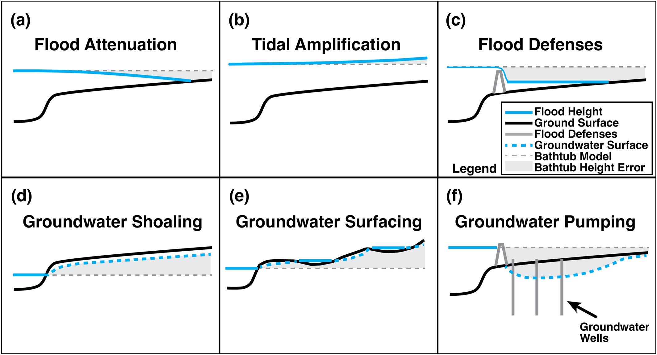
Figure 1: Saunders et al (2024) show that bathtub models do not account for:
(a) how floodwaters slow down, spread, and lose energy due to flow dynamics and friction
(b) increases in tidal water levels caused by tides resonating inside bays and coastal inlets
(c) the effects of flood‑protection structures such as levees and floodwalls, which may be overtopped during extreme events but can still reduce how far flooding spreads inland
(d) rising groundwater tables closer to the land surface
(e) groundwater emerging at the surface due to the combined effects of sea‑level rise and changes in rainfall and recharge
(f) groundwater pumping in areas below sea level that is used to limit flooding caused by rising groundwater levels.
CC BY 4.0 Saunders et al 2024.
Does bathtub modelling over or under estimate?
Several studies have directly compared simple bathtub (static, level‑pool) models with physics‑based hydrodynamic inundation models. Results show that the range of different landforms and processes around the coast means that there is not a straightforward answer: bathtub models can both over‑estimate and under‑estimate inundation extents, depending on coastal setting, connectivity, and processes considered.
However, it could be useful to keep in mind.
In estuaries:
- simple bathtub models often over‑state inundation in estuaries because they assume ocean water levels propagate inland unmodified
- in reality, there can be tidal amplification or tidal attenuation depending on geometry, friction, bathymetry, and resonance
- because the estuarine behaviour varies widely, no uniform trend can be assumed.
On the open coast, a bathtub models commonly under‑estimate inundation during extreme events because they do not account for:
- storm surge dynamics
- wave setup and runup
- wind forcing
- timing and duration of extreme water levels.