


At a glance
- A former coastal road between Koper and Izola in Slovenia was removed due to sea-level rise impacts and redeveloped into sustainable public space, including a promenade, bike path, and bathing areas.
- The 'Let’s draw the coast' initiative engaged over 1,000 participants and 75 community groups in co-creating ideas for the site, with suggestions integrated into the regional spatial plan.
- Success factors included strong foresight by decision-makers, an integrated coastal zone management approach, and active public involvement across all planning phases.
- Challenges included high costs (approx. €156 million) and pressure from potential investors that could compromise public interest outcomes.
Let's draw the coast
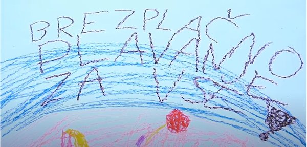
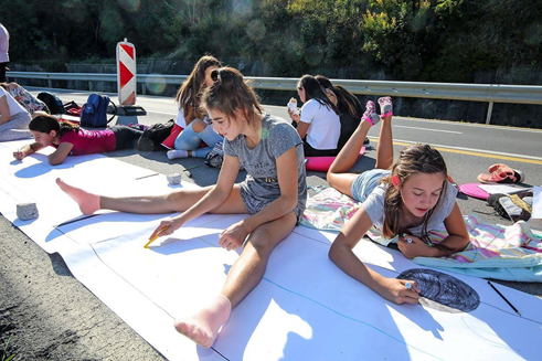
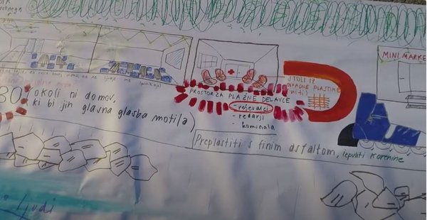
‘Narisimo obalo’ or ‘Let’s draw the coast’ involved more than 1000 people from across Slovenia and other European countries who came together at the site of the old coastal road between Koper and Izola. They made suggestions about the future use and look of the site road and drew their ideas on a 750m long paper roll stretched along the old road.
The former 5km-long road was subject to the impacts of sea level rise as well as spoiling an attractive natural landscape. Since the 1990s, calls had been growing for decongestion of the coast and developing its use for recreation.
Finally, a plan for a new road, including a tunnel, was confirmed in 2004 and the tunnel was opened to traffic in 2015. Other improvements that followed included a biking lane, toilets and benches. The Municipality of Koper also arranged access to the sea and public lighting.
WATCH: a video showing the 'Let's draw the coast' event, which brought together 75 community groups including about 1000 individuals to gather community input in retreating a coastal road.
Engagement activity draws a crowd
Young people, members of civil society as well as primary and secondary school students were particularly well represented at the all-day event. PiNA studied all the suggestions and integrated them into a written analysis, which informed the regional spatial plan.
drawing a road

Participants expressed their views on the future, coastal arrangements and use. The results were elaborated and publicly presented.
- @Tomaz Primozic/FPA info@primorske.siimage-5

Participants expressed their views on the future, coastal arrangements and use. The results were elaborated and publicly presented.
@Tomaz Primozic/FPA info@primorske.si
The decision to take the road through a tunnel demonstrates an emerging environmental consciousness and sensitivity to the spatial quality of the coast, followed by awareness of the urgency of climate change adaptations.
A regional spatial plan for this part of the coast to become a sustainable public space includes elements such as a coastal promenade with access to the sea, piers and the raising of the area to adapt to climate change.
The numerous workshops and tenders dealing with the arrangement of this coastal space over two decades resulted in ‘Let’s draw the coast’, involving about 1000 participants in active co-creation of the vision of the space.
The Public Institute for Entrepreneurship (PiNA) implemented this initiative in 2018, supported by the Municipality of Izola, some ministries, the European Social Fund and Interreg V-B Adrion.
Young people, members of civil society as well as primary and secondary school students were particularly well represented at the all-day event. PiNA studied all the suggestions and integrated them into a written analysis, which informed the regional spatial plan.
Success and limited factors
The success factors in the managed retreat of the coastal road and its sustainable redevelopment began with the foresight of the decision makers at both national and local levels who decided that, despite the significant cost, a new 2.2km long tunnel would be built to enable the removal of the road. This, in turn, allowed an arrangement which is less susceptible to climate change impacts while also giving priority for local people to use the land as a public space, thus enabling more sustainable development.
An integrated approach to the management of the area successfully combines the interests of various sectors and actors in the framework of integrated management (particularly the protection of natural and cultural heritage).
Importantly, the general public were actively involved in the different phases of vision development and determining future use of the space. Previous experience in the field of integrated coastal zone management (ICZM) was also important.
Experts, such as the Chamber for Architecture and Spatial Planning are involved in the landscape planning phase, which is important to identify solutions that will need to comply with the protocol on ICZM.
Limiting factors include pressure from potential investors, which could derail comprehensive public interest arrangements.
The community was actively involved in the different phases of vision development and determining future use of the space.
- @Tomaz Primozic/FPA info@primorske.simore detailed image

The community was actively involved in the different phases of vision development and determining future use of the space.
@Tomaz Primozic/FPA info@primorske.si
Costs
The costs of the diversion and construction of the new route and redevelopment of the former road is approximate and was calculated in 2022, but as a guide:
- Road construction: €150 million (National Programme for Motorway Construction)
- Road closure and associated temporary traffic arrangements €1 million (municipalities of Koper and Izola
- Redevelopment of the former road into bike path, promenade, bathing area and underwater archaeology park (from inception to construction) is estimated at €5 million
To cite:
This case study was prepared by NCCARF. Please cite as: NCCARF, 2024: Community draws the coast in the managed retreat of a road in Slovenia. Case study for CoastAdapt, National Climate Change Adaptation Research Facility, Griffith University, Gold Coast.