


At a glance
- A fish-friendly seawall has been designed and constructed at a pilot site in Moreton Bay, Queensland. The wall was constructed in 2023, with four fish-friendly rock fillets used to protect about 100m of shoreline.
- The project demonstrates the challenges, opportunities and risks involved in implementing a nature-based solution to address coastal erosion.
- At the site, in the North Pine River estuary, the coastline is receding at a long-term rate of about 0.5m per year. The bank is being undercut due to wind generated waves, boat wash and periods of high velocity river flow.
- The seawall design uses shallow rock fillets to create a low-energy zone to attract mangrove growth, which will in turn protect the bank. By minimising the role of hard engineering the project used about half the volume of rock in a typical revetment and so reduced costs.
Eroding estuarine banks
The site at the John Oxley Reserve, on the North Pine River at Murrumba Downs, Queensland spans about 120m of eroded estuarine banks. Analysis using aerial imagery indicates that up to 5.6m of erosion has occurred over the past 11 years.
The site has a history of sand and gravel extraction that began in about 1958, changing the local hydrodynamic processes and extent of riparian vegetation. In the local government area of Morton Bay, the site is now a public reserve surrounded by housing development. Nearby banks have extensive mangrove coverage, but mangrove growth is limited at the reserve due to the high wave exposure and erosion. Observations during field work indicate that the main cause of erosion is the impact of boat wake waves.
The need for bank protection
A rock fillet is a submerged, low-level rock structure designed to deflect wave and current action, encourage the build-up of sediment and promote the germination of mangroves. While this type of nature-based coastal resilience approach is increasingly being recommended for coastal management, it has not been widely used in Queensland, due to a lack of design guidance and case studies. This project was designed and constructed at a pilot site and will provide a case study to be shared with other councils.
The aims of the bank protection were: to stabilise the riverbank; protect the bank from further erosion and fragmentation; and, through nature-based designs, allow the site to be self-sustaining in terms of riverbank stability and ecological connectivity. A number of options were considered and assessed based on aesthetics, environmental impact, design complexity, buildability and cost. The rock fillet approach was identified as the preferred approach to be taken through to the design stage.
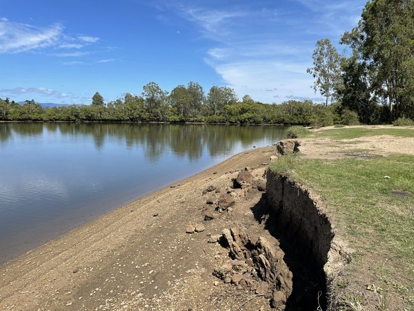
Considerable erosion had occurred along the banks, mostly due to waves created from boat wake.
- © JBPacific Pty Ltd.Fish-friendly

Considerable erosion had occurred along the banks, mostly due to waves created from boat wake.
© JBPacific Pty Ltd.
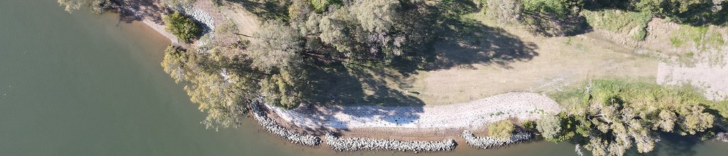
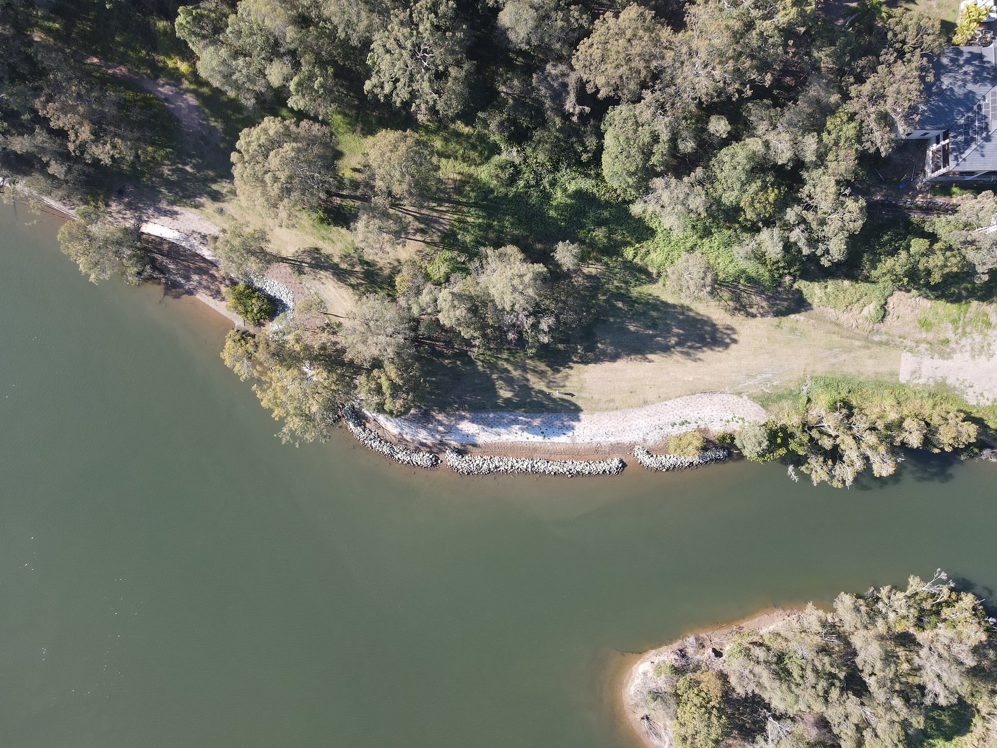
The shape of the rock fillets (like a tick mark) provides a growing area for new mangroves and access for fish to swim in and out. It is more like a small breakwater than a seawall.
The fillets are constructed of loose placed rocks, which are connected to the bank at one end and extend into the river before turning to run parallel to the shore. The design includes four rock fillets, underlying geofabric, a bank regrade and initial vegetation planting.
An initial round of mangrove planting was undertaken within the area protected by the fillets, using seedlings grown from locally sourced propagules.
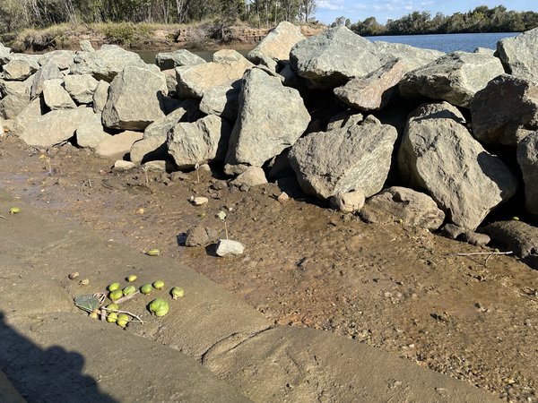
The fillets are constructed of rocks placed loosely over geofabric following a bank regrade and initial vegetation planting.
- © JBPacific Pty Ltd.fish friendly - rocks

The fillets are constructed of rocks placed loosely over geofabric following a bank regrade and initial vegetation planting.
© JBPacific Pty Ltd.

The rock fillets are shaped like a tick mark and act like a small breakwater.
- © JBPacific Pty Ltd.Fish-friendly
The rock fillets are shaped like a tick mark and act like a small breakwater.
© JBPacific Pty Ltd.
Navigating the approval process
Undertaking this type of project requires a variety of approvals and permits under the various State planning acts, including the Coastal Protection and Management Act 1995 and the Planning Act 2016. To ensure the work ran on time and on budget, the project team consulted with the relevant stakeholders from the initial concept design, through to follow-up meetings before lodging the plans. In this way they were able to keep the state government involved in the design and seek feedback and guidance on what would be required as part of the assessment process.
Comments from the different state government departments led to minor amendments being made to the design to ensure a streamlined approval process while still ensuring the desired outcome. The development approval process took about eight months.
Challenges and recommendations
The project was constructed successfully in 2023 although several modifications were made to the design during works.
The rock fillet crest height was designed and originally constructed at mean high water level. While this would provide protection for most of the tidal window, on the peak high tide there is more boat traffic in the nearby boating lane, with wakes regularly passing over the crest of the structure. They therefore decided to raise the crest to the mean high water spring tide level to offer more protection during this period.
The planned construction involved grading the bank before placing the rock fillets. This meant the regraded bank was exposed to boat wake until the fillets were installed. Even though it was only a limited time, this resulted in further wake-wave erosion to the bank. For future projects, it’s recommended to complete the fillets before the bank is reprofiled.
For other groups looking to implement nature-based erosion protection in South-East Queensland, recommendations include:
- involve a land use planner early to ensure design and technical reports meet state and local government requirements
- organise pre-lodgement meetings with the state and council
- engage a qualified consultant to identify any marine plants and collect mangrove propagules and riparian vegetation seedlings before construction begins to ensure they are ready for planting
- increase the height of the rock fillet in areas of more significant waves during a high tide.
To cite:
This case study was prepared by NCCARF. Please cite as: NCCARF, 2024: Building a fish-friendly estuarine seawall. Case study for CoastAdapt, National Climate Change Adaptation Research Facility, Griffith University, Gold Coast.