


Finalising vulnerability mapping - after a rocky start
Becoming the first LGA in NSW with a mapped coastal vulnerability area did not initially go to plan. The initial approach was found to be too onerous and not in line with community expectations.
The Coffs Harbour City Council (the City) then redrafted the framework to result in a merits-based approach and acknowledged that LGA-scale data could never replace site-based assessments.
The framework now requires a new development seawards of the coastal vulnerability area to address coastal hazards as part of the development process. If the risk is manageable, the application can proceed: if not the development cannot be approved without modifications.
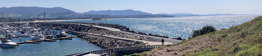
CS_Coffs_seawall

Constructed in 1917, Coffs Harbour seawall protects the harbour and seaward access to the port.
© D. Greenhalgh
The Coffs Harbour region and planning context
The project covers all of the Coffs Harbour LGA, which is located on the mid north coast of NSW. The LGA is home to more than 78,000 people with services and industries like health and education campuses being critical anchors and the airport further diversifying the local economy. The area supports a highly productive agricultural hinterland, including a nationally significant blueberry industry.
Recreation and tourism are important contributors to the Coffs Harbour economy; the Coffs Coast is an accredited eco-destination with significant natural areas including the Solitary Islands Marine Park, and Bongil Bongil and Bindarri National Parks.
The City notes in its Climate Change Policy, that a changing climate will affect the current and future way of life across the entire Coffs Harbour community and the natural and built environments. The City has a key role to play in providing leadership and education to help the community and business to understand and accept responsibilities to address climate change.
This project provides leadership to the community by outlining the City’s expectations in relation to coastal hazards and guidance to the development industry by requiring coastal vulnerability to be addressed in future developments.
Planning for future development
The issue of coastal erosion in NSW, and beyond, is well documented, however it remains difficult to implement successful planning frameworks. The City adopted an approach that will ensure each development is assessed on its merits if it is within the mapped Coastal Vulnerability Area.
The requirements do not quarantine, or ‘sterilise’, areas from development: instead, it requires landholders to demonstrate that designs meet the coastal risks of the site for the lifespan of the structure. This merits-based approach is similar to the approach taken for bushfire and flood risk and acknowledges that LGA-scale data can never replace a site-based assessment.
In ensuring that new development is more resilient to coastal processes, the City is reducing the burden on future generations of inappropriate development: such development, if affected by future coastal hazards, could require major public expenditure.
Resilient development that considers known and predicted risk will also provide better outcomes for landowners in terms of risk to life and property.
Developing the plans and policy
The City first began work in 2014 to plan for its current and future coastal area. However the original iteration included elements of planned retreat that were not acceptable to the community. In 2015, the project was put on hold due to community concerns and pending coastal reforms. Recommencing in 2018, the project was finally completed in 2023. This included the years taken by the state government to approve the legislative changes. The planning framework was developed with existing staff resources and no additional budget.
There is a legislated process for including a Coastal Vulnerability Area in the NSW Resilience and Hazards State Environmental Planning Policy 2021: however, the City is able to determine the content of the Development Control Plan, the policy and which data to use.
The City followed a merits-based approach that asks the landholder to demonstrate that the design meets the coastal risks of the site for the life span of the structure. This merits-based approach is similar to the approach taken for bushfire and flooding. It also acknowledges that LGA-scale data can never replace site-based assessments.
In determining which data to use, the City referred to its Coastal Zone Management Plan (CZMP). This includes nine lines: coastal hazards mapping for three time horizons (immediate, 2050 and 2100) and three likelihoods (almost certain, unlikely and rare). The project adopted the ‘2100 unlikely line’ as it allowed for the precautionary principle but was not overly onerous.
The project also considered whether to include coastal inundation. The data was analysed and found to be less accurate than the existing flood prone land mapping — developed as part of Floodplain Risk Management Plans — that already include a range of scenarios, including climate change and coastal inundation. As a result, the City decided to exclude coastal inundation from this project as it was already addressed in the Floodplain Risk Management Plan process.
Community consultation
The project had been put on hold in 2015, as a result of community concern. Following the NSW State Government coastal reforms in 2018, the City took a fresh look at the project and focused on a merits-based approach similar to that used for other constraints such as bushfire or flooding. The new approach, which was developed in consultation with the NSW Government, took more than a year to produce and included a commitment to community consultation.
The community consultation process involved writing to every landholder with property (1400 in total) in the proposed Coastal Vulnerability Area. It also included many conversations about the framework and how it would impact individual properties. The first iteration of the planning process in 2014 generated 111 submissions: the revised approach yielded only eight submissions, which was considered to indicate community acceptance of the plan.
The City of Coffs Harbour is the first LGA with a mapped Coastal Vulnerability Area in the NSW government’s Resilience and Hazards State Environmental Planning Policy 2021. This is supported by a Development Control Plan and a Policy. Proposed developments in the coastal vulnerability area will require? further assessment and advice from a coastal engineer.
The mapping will be reviewed and updated as part of the Coastal Management Program for the open coast that commenced in late 2023.
Lessons learned
There are two important lessons from this project.
- Planning frameworks can still give great results via a merits-based assessment that is not overly restrictive: expensive fine grain data on a LGA scale is not needed if the right approach is taken, i.e., the planning controls are equal to the accuracy of the data.
- The City learned that they needed to change tack to ensure the community was on-board. Taking notice of community feedback that its initial proposed framework was too restrictive, it changed its approach.
This project is very transferable to other councils. Now that the NSW Resilience and Hazards State Environmental Planning Policy 2021 includes coastal vulnerability mapping for the Coffs Harbour LGA it should be easier for other LGAs to submit data for consideration.
Other LGAs should ensure that the planning controls are equivalent to the accuracy of the data and consider a merits-based approach.
Further information
- Coastal Vulnerability Area Policy
- Development Control Plan - Chapter E2
- Have Your Say Community Consultation Page
- Coastal Vulnerability Map
This case study was prepared by Sally Whitelaw, CHCC. Please cite as: Whitelaw, S, 2024: Coffs Harbour: NSW's first local government to finlise Coastal Vulnerability Mapping. Case study for CoastAdapt, National Climate Change Adaptation Research Facility, Gold Coast.