


At a glance
- Drainage can be a driver of design: A UWA project Place Value Ashfield focuses on drainage as a central design element in urban infill, using water flows – surface, subsurface, and stormwater – as guiding systems for planning and development.
- The project responds to Perth’s fragile water systems, particularly in Ashfield where urbanisation threatens the aquifer-fed Ashfield Flats wetland. Design strategies aim to preserve natural infiltration and water quality.
- Blue-green Infrastructure such as streets, verges, and parks are use as interconnected ecological and drainage corridors, supporting biodiversity, cooling, and aquifer recharge while integrating with daily urban life.
- Water-sensitive urban design (WSUD) offers infill strategies that incorporate permeable surfaces, rain gardens, and lightweight construction to minimise impervious footprint and mimic natural hydrological cycles.
- Collaborative, landscape-led planning used in this project beings together designers, government, and the community to develop shared hydrological framework that uses drainage as a system that can underpin climate-adapted cities.
Perth’s deep time landscape: Biodiversity, culture, and a changing water system
Perth sits on the Swan Coastal Plain, a sandy interface between the Indian Ocean and the ancient Yilgarn Plateau. Perth and Southwest Australia are among the world’s most ancient regions, with continuous Noongar settlement for over 60,000 years. The Whadjuk people, Traditional Custodians of this Boodjar, sustain a deep, reciprocal relationship with the land.
Perth’s has a Mediterranean climate with very wet winters and very hot and dry summers. Despite extensive land clearing, Perth remains ecologically vital due to its rich biodiversity. With more than 1,800 native plant species, Perth is globally recognised as a Hotspot City within the Southwest Australia Biodiversity Hotspot – one of 36 regions where exceptional biodiversity is seriously threatened.
Over millennia, estuaries like the Swan-Canning (Bilya) formed through complex interactions of sediment, groundwater, and tidal flows. These landscapes once supported vast wetlands fed by aquifers, many thousands of years old. Since colonisation, over 70% of Perth’s wetlands have been filled. The city’s aquifers – like the deep Yarragadee – have been pumped and its rivers dammed, dredged, and edged in concrete. Today, rainfall and streamflow are in decline: the city sources nearly half its water from energy-intensive desalination.

Figure 1. Bioregional mapping of the ancient wetlands of the Swan Coastal Plain, today many of these have been covered by the sprawling urban footprint of Perth
- © Daniel Jan Martin, UWA.Fig1
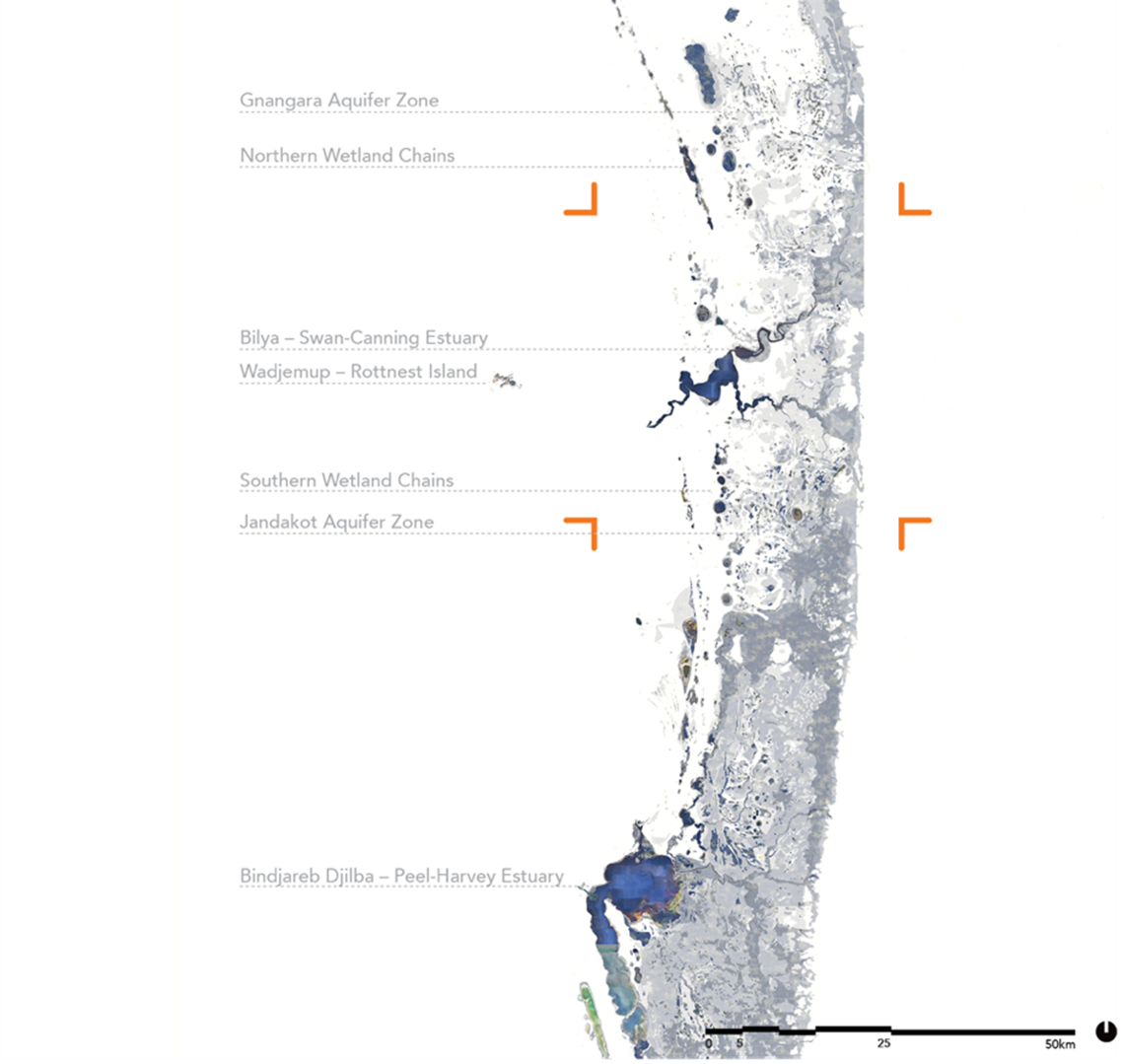
Figure 1. Bioregional mapping of the ancient wetlands of the Swan Coastal Plain, today many of these have been covered by the sprawling urban footprint of Perth
© Daniel Jan Martin, UWA.
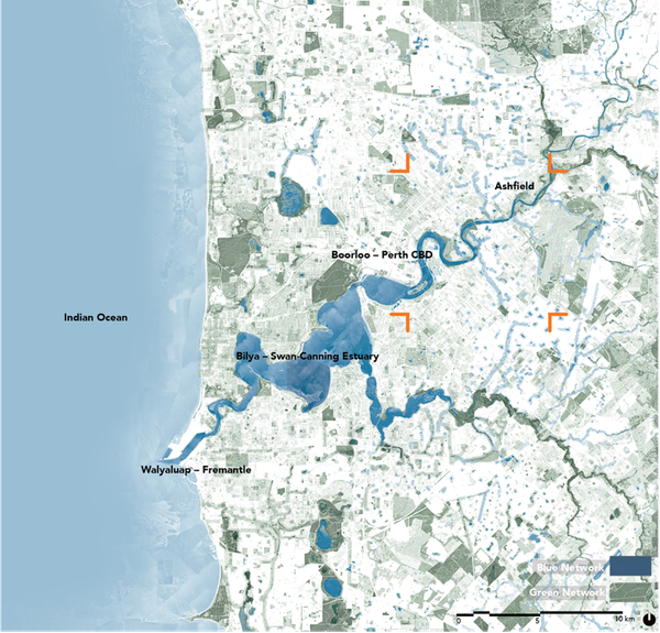
Figure 2. Mapping of the contemporary blue and green networks of Perth, centring on the Bilya Estuary.
- © Daniel Jan Martin, UWA.Fig2

Figure 2. Mapping of the contemporary blue and green networks of Perth, centring on the Bilya Estuary.
© Daniel Jan Martin, UWA.
Place Value Ashfield
Ashfield is a small riverside suburb just 15 minutes by train from Perth’s CBD. Situated beside the Bilya Estuary, Ashfield overlays a delicate hydrological interface of surface and subsurface flows. The adjacent Ashfield Flats – one of the last remaining wetland systems in the urban region – depends on stable aquifer-fed water regimes. These flows are increasingly threatened by urbanisation, particularly from infill development that replaces permeable ground with concrete pads and removes tree canopy critical to evapotranspiration and stormwater management.
The project Place Value Ashfield places drainage at the heart of its design approach. Rather than treating water as a problem to be piped away, the project treats drainage as a guide for urban form – a living infrastructure to be protected, revealed, and extended.
The team examined Ashfield across time and scale, placing it within Perth’s broader bioregional context to address local threats. This led to a strategic framework guiding best-practice development at the lot scale. Central to the approach is a landscape strategy introducing green corridors that support sensitive infill housing which enhancing ecological resilience.
READ: more about Place Value Ashfield
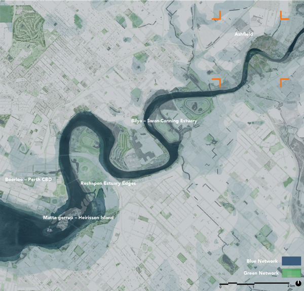
Figure 3. City-scale mapping of historic estuary edge overlaid with contemporary blue and green networks, locating Ashfield as part of the Bilya Estuary system.
- © Daniel Jan MartinFig3

Figure 3. City-scale mapping of historic estuary edge overlaid with contemporary blue and green networks, locating Ashfield as part of the Bilya Estuary system.
© Daniel Jan Martin
This led to the design of urban typologies such as mid-rise courtyard homes, terraces, and mixed-use housing to minimise impervious footprint, retain mature trees, and maximise opportunities for rain gardens, bioswales, and permeable surfaces. These approaches reduce the rate and volume of stormwater runoff, enhance water quality, and mimic natural hydrological cycles that have been disrupted by conventional suburban expansion.
A key innovation was mapping and restoring ecological corridors that double as drainage paths – what the project refers to as “blue-green infrastructure.”
By stitching together rail-to-river corridors through backyards, streetscapes, and parks, Place Value Ashfield enables water to move through the suburb in visible and functional ways. Streets become stormwater collectors and habitat corridors. Verges and laneways are vegetated to filter runoff and promote aquifer recharge. In this way, drainage infrastructure becomes a civic amenity that helps to cool the suburb and enhance biodiversity, and offering a richer public realm.
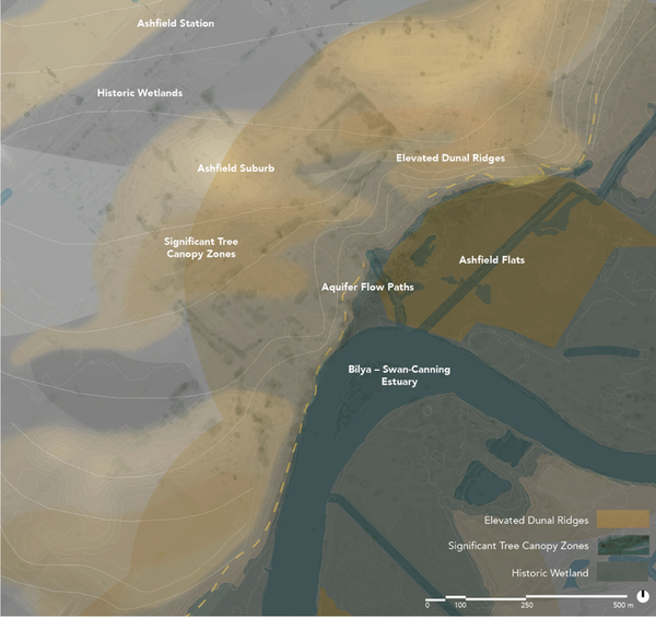
Figure 4. Precinct scale mapping of the detailed ‘deep’ water, surface water and urban ecological priorities in the suburb of Ashfield. Author: Daniel Jan Martin.
- © Daniel Jan MartinFig4

Figure 4. Precinct scale mapping of the detailed ‘deep’ water, surface water and urban ecological priorities in the suburb of Ashfield. Author: Daniel Jan Martin.
© Daniel Jan Martin
At the scale of the lot, Water Sensitive Urban Design (WSUD) is implemented through lightweight building construction, clustered footprints, and careful grading. By retaining natural slopes and soil profiles, these strategies help direct water back into the ground rather than overwhelming downstream systems. In contrast to standard infill, which often clears and levels sites indiscriminately, these techniques allow for a finer-grain development pattern that respects the existing hydrology.

Figure 5. view of Ashfield details the landscape and housing strategy, connecting river and rail via an upgraded urban and ecological realm supporting new medium-density housing typologies. .
- © Daniel Jan MartinFig5
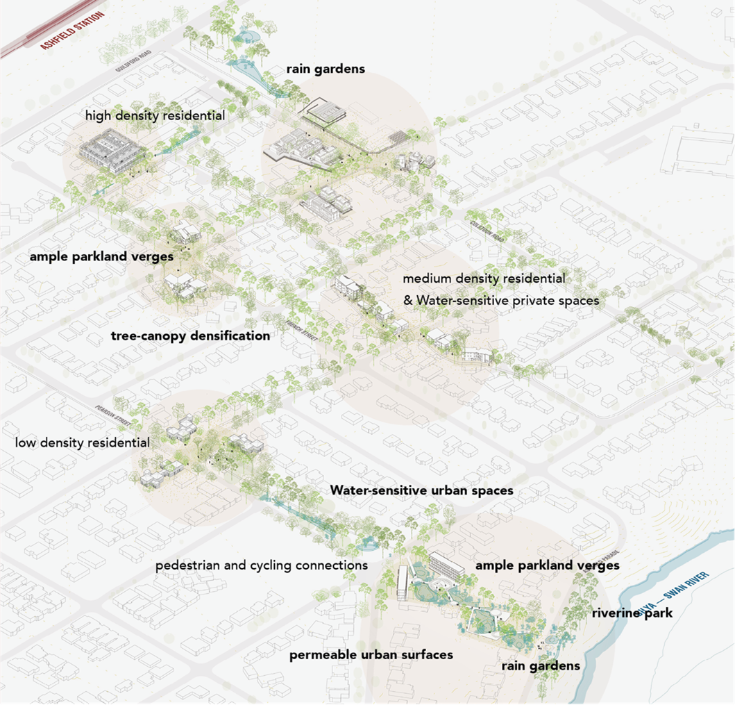
Figure 5. view of Ashfield details the landscape and housing strategy, connecting river and rail via an upgraded urban and ecological realm supporting new medium-density housing typologies. .
© Daniel Jan Martin
The strategy is especially timely as Perth grapples with the dual threats of climate change and a booming population. With increasing rainfall variability and heatwaves, managing stormwater effectively supports goals of both ecological and public health.
The hardening of cities exacerbates flash flooding and urban heat island effects, which both disproportionately affect vulnerable communities. By focusing on drainage, Place Value Ashfield offers a replicable model for how to densify without compounding these risks.
Importantly, the project worked across disciplines and stakeholders – from landscape architects and hydrologists to community members and government agencies – to build a shared understanding of drainage as a core urban system. The result is not only a set of design proposals, but a offer a shift in mindset: from treating water as an engineering constraint to seeing it as a lifeline for urban resilience.
To cite:
This case study was prepared by NCCARF. Please cite as: NCCARF, 2024: Designing for drainage: urban infill through hydrology in a Perth suburb. Case study for CoastAdapt, National Climate Change Adaptation Research Facility, Griffith University, Gold Coast.